
Information
Northern Xinjiang Panorama Self-Driving Tour (14 Nights/15 Days)
Classification:
Day 1 Beijing-Urumqi Flight Information: CA1293 08:20/12:30
Today we will gather at the domestic airport and take a flight to 【Urumqi】, starting our journey in Xinjiang. Upon arrival, a warm guide will greet all guests at the airport, followed by a visit to 【Erdaoqiao】 and 【International Grand Bazaar】, and then we will head to the hotel to handle self-driving procedures in the hotel parking lot.
Day 2 Urumqi-Tianshan Tianchi 80KM-Wucaiwan 230KM-Fuyun County 500KM
After breakfast, we will head to the 【Tianshan Tianchi Scenic Area】, visiting the "Heavenly Pool" at the Bogda Peak of the Tianshan Mountains, enjoying the beautiful scenery of the snow-capped mountains reflected in the lake, the green waters, the stone gate, the East and West Tianchi, and the Dihai Shen Zhen, while gazing at Bogda Peak. Experience the simple customs of the horse-riding ethnic group, the Kazakhs. We will continue to Fuyun County, passing by the 【Karamayli Nature Reserve】 for sightseeing. This area, originally a desert, is home to a large number of wild animals, making it a rare wildlife viewing spot in China. Once you get close to Karamayli, animal droppings and footprints can be seen everywhere. Various wild ungulates such as Przewalski's horse, Mongolian wild donkey, and gazelles thrive here; golden eagles and hunting falcons either perch on solitary peaks or soar in the sky; in autumn, flocks of sand grouse cover the ground, and hundreds of migrating raptors fly across the sky, creating a spectacular and shocking scene. After arriving, check into a local hotel.
Day 3 Keketohai-Fuhai County 260KM
After breakfast today, we will visit the 【Keketohai Scenic Area】, located in the Fuyun County of the Altay region in northern Xinjiang. The scenic area mainly consists of the Karaxiang'er earthquake fault zone, Kokesu Lake, Yilimu Lake, and the Erqis Grand Canyon, combining beautiful canyon river source scenery, wetland landscapes, cold extreme lakes, geological mineral resources, and other natural landscapes, integrating grassland nomadic culture, Western ethnic customs, and regional folk characteristics. It is a national 5A-level tourist attraction and an international original ecological tourism area, featuring sightseeing tourism, leisure vacations, special tourism (hiking, photography, etc.), and scientific research. We will visit the representative of China's rare metal key mining areas - Pit No. 3 and the exhibition hall. After the visit, we will drive to Fuhai County.
Day 4 Fuhai County-Ulungur Lake Ring Road-Jiadenyu 340KM
After breakfast, we will drive on the 【Ulungur Lake Ring Road】, enjoying the beautiful scenery around Ulungur Lake, located in the north of the Junggar Basin, northwest of Fuhai County. "Brentuo" means "bushy" in Turkic. This is the second largest fishery base in Xinjiang after Bosten Lake. It consists of two water bodies: Jili Lake (Xiaohaizi) with an area of 165 square kilometers and Ulungur Lake with an area of 730 square kilometers. The Ulungur River, originating from the Altai Mountains, flows into it, serving as the main water source for the lake. The average depth of the lake is eight meters, with cliffs on the north shore, only 2.1 kilometers away from the Erqis River. The lake basin was formed by fault subsidence. Ulungur Lake is famous for its "Gobi Sea" and delicious "Fuhai fish". We will then drive to Burqin-Kanas 【Jiadenyu】, enjoying the beautiful natural scenery along the way, including the Yilzi River - the only river in China that flows into the Arctic Ocean, the Agonggaiti Grassland, and Russian villages. Upon arrival, check into a hotel for easy access to the 【Kanas Scenic Area】 the next day.
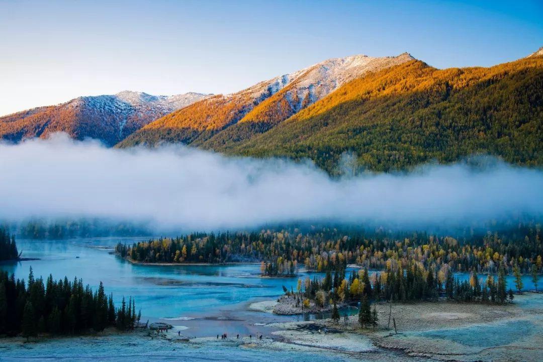
Day 5 Jiadenyu-Kanas Scenic Area-Hemu-Jiadenyu 120KM
Before dawn, we will set off to see the morning mist (including direct shuttle service to the scenic area, with different vehicle types from 7 to 45 seats, avoiding the hassle of queuing for tickets and waiting for transfers, allowing for spontaneous stops and visits, making it easy to enjoy the beautiful scenery of Kanas Lake and Hemu Village throughout the day), heading to the highlight of this trip - the 【Kanas Scenic Area】. We will follow the original birch forests, the mirror-like Wulong Bay, the beautiful and tranquil Moon Bay, the rippling Fairy Bay, and Yaze Lake, arriving at the large lake area for sightseeing. We will take the shuttle to the Fish Viewing Pavilion, overlooking the grand lake scenery and appreciating the lake known as the "Color Changing Lake". After the visit, we will head to 【Hemu Village】, checking into a local boutique homestay. The houses in Hemu Village are made of logs, giving it a primitive feel, originally a village inhabited by the Tuvan people. It has not been damaged by any modern buildings, and the log-colored houses blend perfectly with the natural vegetation, with the outdoors filled with Gesang flowers, looking as beautiful as a painting. Many people call it "Little Switzerland of Xinjiang", but personally, I think they are two different kinds of beauty, though everyone has their own feelings.
Day 6 Jiadenyu-Wucai Beach-Burqin-Uluwha Devil City 380KM
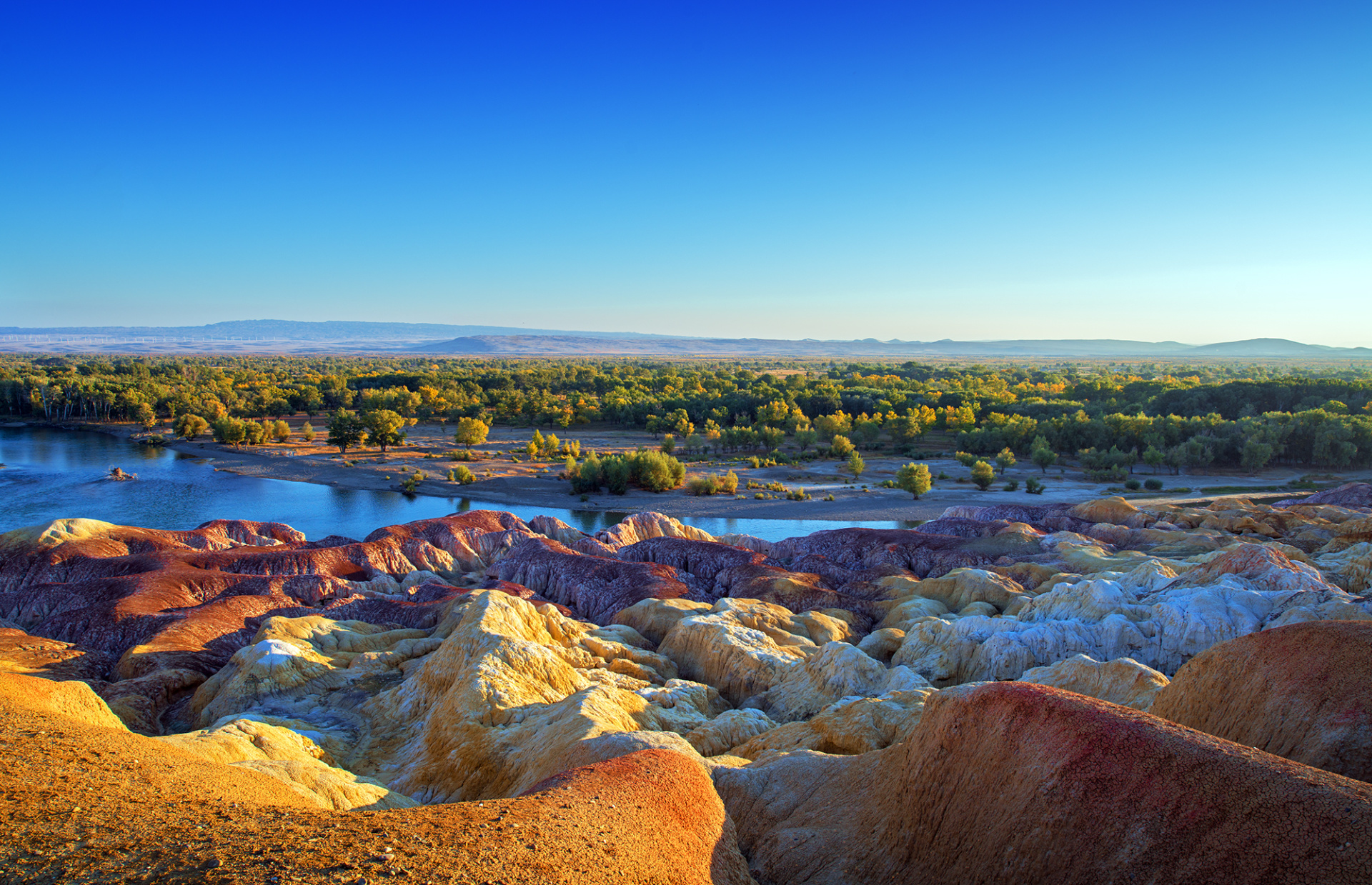
After breakfast, we will continue to enjoy the beautiful scenery in Hemu in the morning. In the afternoon, we will head to 【Wucai Beach】, where the hilly geology is unique, displaying various colors. Every evening, when the sunset shines, the colors are splendid and magical, creating a spectacular view. On the opposite bank is a dense poplar forest, beautifully reflected in the river, making it an excellent spot for photography, especially in autumn when the yellow leaves are brilliant. After the visit, we will head to Karamay Uluwha, to the famous 【World Devil City】, located in the Uluwha District of Karamay City, Xinjiang Uygur Autonomous Region, about 90 kilometers northeast of Karamay City, approximately 5 kilometers east of Uluwha Township, at longitude 85°19′ and latitude 46°6′ (310 kilometers east of National Highway 217), with an elevation of 300-500 meters, averaging 380 meters. Uluwha extends northwest to southeast, about 5 kilometers long and 3 kilometers wide, covering an area of about 15 square kilometers, consisting of a series of isolated mesas oriented nearly northwest to southeast. The mesas are 10-50 meters high, composed of widely exposed Cretaceous lower Turgut group, mainly consisting of shallow lake and gray-green fine sandstone, brown and reddish-brown mudstone, and sandy mudstone, with the Turgut group slightly horizontal, gently tilting southeast at an angle of about 5 degrees. In the evening, the golden light at sunset brings the entire scenic area to life, presenting extraordinary scenery.
Day 7 Uluwha-Karamay-Sailimu Lake 490KM
After breakfast, depart by car to visit the magnificent 【Sayram Lake Scenic Area】. Along the way, pass through the Karamay oil field operation area, poplar forests, and Gobi desert. Sayram Lake, formerly known as the Western Pure Sea, is called Sayram Naur in Mongolian, meaning the lake on the ridge. Sayram Lake is located in the western Tianshan Mountains, 9360 kilometers southwest of Bole City, in the Bortala Mongol Autonomous Prefecture of Xinjiang. The Urumqi-Ili highway runs along the southern shore of the lake, which has an elevation of 2073 meters, a water area of 458 square kilometers, an oval shape, approximately 30 kilometers long from east to west, about 25 kilometers wide from north to south, a circumference of 90 kilometers, a maximum depth of 92 meters, and a total water storage of 21 billion cubic meters. It is the highest and largest alpine lake in Xinjiang. In the evening, enjoy the sunset, admire the night view and starry sky by the lake, and taste fine wine (self-selected and prepared).
Day 8: Sayram Lake - Guozi Pass Bridge - Horgos Port - Lavender Garden - Yining City 380KM
After breakfast today, we will set off by car to start today's journey. 【Guozi Pass Bridge】 is the first cable-stayed bridge and the highest bridge in Xinjiang, the largest and most important bridge in Xinjiang, and also the first highway steel truss cable-stayed bridge in the country. It integrates new technology, new structure, new process, and new equipment, representing a major breakthrough in the history of highway construction in Xinjiang. It is the first time in Xinjiang to use large-volume concrete temperature control technology, asynchronous construction technology for tower beams, hydraulic climbing formwork, and self-propelled movable formwork, accumulating valuable experience for highway construction in mountainous areas. After the project is completed and opened to traffic, it will solve the travel difficulties in the Ili River Valley, allowing direct access from Ili Prefecture to Urumqi at any time, which is of great significance for the stability and economic development of border areas. 【Horgos Port】 is the largest land and railway comprehensive port in Xinjiang and the first port in Xinjiang. It is located in Horgos City, Ili Kazakh Autonomous Prefecture, Xinjiang, facing Kazakhstan across the Horgos River. Horgos Port is the starting and ending point of the Yihuo Railway, Lianhuo Expressway, National Highway 312, and the China-Central Asia natural gas pipeline. The port construction has reached a certain scale, with supporting facilities such as border inspection stations, customs, health quarantine, animal and plant quarantine, commodity inspection, postal services, banks, television stations, and hotels. There is also a border trade area approved for establishment by the State Council in July 1992. Another scenic spot at the port is the national gate and boundary monument, symbolizing the sovereignty of the People's Republic of China, located about 50 meters from the boundary monument, inscribed with the bright red and eye-catching word "China" and an exquisite national emblem. A bridge next to the boundary monument marks the dividing line between the territories of the two countries. China and Kazakhstan are connected by mountains and rivers, and the people of both countries have many ties. Since the opening of Horgos Port, the exchanges between the people of the two countries have been increasing. 【Hocheng Lavender Garden】 June is the most romantic season in the Ili River Valley, with lavender blooming across tens of thousands of acres. The northern foothills of Tianshan in Xinjiang are located in the same latitude as Provence, France, and have similar climatic and soil conditions, making it a lavender planting base and the hometown of lavender in China. The lavender in Xinjiang has been listed as one of the eight famous varieties in the world. It usually blooms in June. Whenever the flowers bloom and the wind blows, the entire lavender field appears like deep purple waves rolling up and down, which is very beautiful. 【Kazanchi Folk Street】 (if taking a horse-drawn carriage 150) is the only large-scale original ecological cultural scenic area in northern Xinjiang that reflects Uyghur customs. It is a window to the urban image of Ili and a vivid portrayal of ethnic customs. It encompasses the rich Uyghur culture of southern Xinjiang while not losing the unique customs and traditions of the Uyghurs in northern Xinjiang, joyful and bright yet not lacking in solemnity...
Day 9: Yining City - Yizhao Highway - Zhaosu Wetland Grassland 150KM
After enjoying breakfast today, we will drive on the road known as "Little Duku" 【Zhaosu Highway】, admiring the beautiful scenery along the way. Then we will arrive to visit 【Zhaosu Wetland Park】, where the abundant river water, fertile land, and excellent environment attract thousands of birds to inhabit and breed. From mid-September to early October each year, during the bird migration period, various bird species can be seen in Zhaosu.
Day 10: Zhaosu - Qiongkushitai Village 150KM
After breakfast today, we will drive to the idyllic Kazakh pastoral village 【Qiongkushitai Village】, enjoying the beautiful scenery along the way. Qiongkushitai means "big platform" in Kazakh. The Qiongkushitai area is rugged and has a masculine beauty in the grassland. The plateau is crisscrossed with numerous ravines, depicting the calm grassland like waves rising in the sea. Visitors can see the blue sky, white clouds, silver snow-capped mountains, dark green fir forests, light green grasslands, and colorful flower seas, with distinct layers of colors and harmonious tones, forming a natural picture. In other words, it can also be described as: under the blue sky and white clouds are the snow mountains, under the snow mountains and fir forests is Qiongkushitai, and below Qiongkushitai is Karajun. The Qiongkushitai Village on the Qiongkushitai grassland is a Kazakh pastoral village, a small village on the northern slope of Tianshan, the northern entrance of the ancient Wusun Road, which was previously unknown. Since the flowers of Tianshan have appeared in the world, its name has been recognized. Almost all the houses in Qiongkushitai Village are wooden structures, some built from whole logs, while others are constructed by splitting logs in half and using various techniques such as hollowing, tenoning, and arching. The village is surrounded by mountains, and the houses are built by the water, with drinking and living water sourced from the Kuerda River, which flows continuously throughout the year.
Day 11: Qiongkushitai - Karajun Grassland - Tekes Bagua City 190KM
After breakfast today, we will bid farewell to this beautiful village and drive to the 【Karakol Grassland】 for sightseeing. It is located in the southern Karakol Mountains of Tekes County, about 50 kilometers from Bagua City, with a simple road connecting it. Backed by majestic snow-capped mountains, the grassland features forests, flower seas, and other landscapes, offering vast and beautiful scenery, making it an excellent spot for sightseeing and photography. It is a must-pass route for many hiking enthusiasts, with lush green grass from May to September and various wildflowers blooming across the mountains. After the tour, we will continue to 【Tekes Bagua City】, the only fully preserved Bagua city in the world. In 1996, the relevant authorities removed the traffic lights on the roads, making Bagua City a city without traffic lights. Legend has it that Tekes Bagua City was originally laid out by Qiu Chuji, one of the Seven True Ones of Taoism during the Southern Song Dynasty. At that time, the real person Changchun, Qiu Chuji, was invited by Genghis Khan to the Western Regions. When he passed through the Tekes Valley, he was moved by the mountains and rivers here, so he laid out this Bagua city. The Bagua city is circular and radiating, with a street layout resembling a magical maze, where every road connects and every street links. At the same time, Bagua City has rich folk customs, profound historical culture, and beautiful natural scenery, with well-preserved ancient Wusun tombs, the site of the "summer capital" of the Wusun Kingdom, stone men on the grassland, ancient tombs of the Xiongnu, ancient rock paintings, and rock wind caves.
Day 12: Tekes - Nalati Grassland 260KM
After breakfast today, we will say goodbye to Bagua City and drive to the famous 【Nalati Grassland】, experiencing the beautiful grassland scenery all day long. As the sun just peeks out, it kisses this grassland with its first ray of sunlight, so the ancestors of the herdsmen gave this land a poetic name: Nalati, meaning "the place that first sees the sun." Nalati Grassland is one of the four major high mountain valley grasslands in the world. Here, blue skies and white clouds, glacial snow peaks, forests and grasslands, and canyon rivers come together, making it the grassland with the highest concentration of Kazakh population in the world. It was once recognized by the Shanghai World Guinness Headquarters as the "grassland with the most Kazakh population" and "the grassland with the most Kazakh yurts," serving as an "open-air museum" that reflects and showcases the traditional lifestyle of the Kazakh people.
Day 13: Nalati Grassland - Southern Duku Highway - Bayinbuluke Grassland 280KM
After breakfast today, we will set off by car and drive along the famous scenic road 【Duku Highway】 to visit 【Bayinbuluke Grassland】, enjoying the beautiful scenery along the way. The 【Duku Highway】 resembles a giant dragon lying across the Tianshan Mountains. At the southern end of the Duku Highway, people will also enjoy the magnificent Kizilya Mountain Scenic Area, where the red mountain stone forest is spectacular. Moreover, nearby, the mysterious Tianshan Grand Canyon Scenic Area is equally stunning, with its winding paths that astonish visitors. In the canyon, there is also a Buddhist cave "A'ai Cave" carved during the Tang Dynasty, featuring exquisite murals, and this area has become an authoritative filming location. The Kuqa River runs alongside the highway, and as the road passes through the "flame zone" on the southern slope of the Tianshan Mountains, it is replaced by steep cliffs, green grass, thorny bushes blooming with yellow flowers, and scattered pine trees. The valley is filled with the fragrance of wildflowers, and the towering peaks are capped with chilling white snow. 【Bayinbuluke Grassland】 is located in the mountainous basin in the northwest of Bayingol Mongol Autonomous Prefecture and Hejing County, surrounded by snow-capped mountains, at an altitude of about 2500 meters. Major attractions include Swan Lake, the Nine Curves and Eighteen Bends, etc. If you are lucky enough to visit here in late June, you can also see beautiful white swans.
Day 14: Bayinbuluke Grassland - Duku Highway - Qiaerma Martyrs Cemetery - Dushanzi 350KM
After enjoying breakfast today, we will drive on the 【Northern Duku Highway】 to the hundred-mile gallery, appreciating the beautiful scenery along the way, passing by 【Qiaerma Martyrs Cemetery】. Upon arrival, we will visit 【Dushanzi Grand Canyon】 and 【Qiaerma Martyrs Cemetery】. One-third of the Duku Highway is cliff walls, and one-fifth of the section is in the high mountain permafrost zone, crossing nearly ten major rivers of the Tianshan Mountains and climbing over four ice passes that are snow-covered year-round. The road builders of that year carved tunnels through the "impassable" passes and built roads where the yellow sheep dared not tread, crossing the insurmountable peaks... To build this road, tens of thousands of soldiers fought for ten years; among them, 168 road builders sacrificed their precious lives, and now they rest quietly in Qiaerma Martyrs Park, the oldest being only 31 years old and the youngest just 16. 【Dushanzi Grand Canyon】, known as the "Duku Secret Realm, a billion-year wonder," is located in the Dushanzi District of Karamay City, Xinjiang, 28 kilometers south of the urban area, accessible by road. The valley bottom is 100-400 meters wide, the valley shoulder is 800-1000 meters wide, and the height from the valley bottom to the valley shoulder can reach 200 meters, with an altitude of 1070 meters, belonging to canyon landforms. It has been featured in National Geographic magazine, recognized as the most beautiful road in the country, and is a filming location for the TV series "The Legend of the Nine Provinces" and the movie "Riding the Wind and Breaking the Waves."
Day 15: Dushanzi - Urumqi 230KM Urumqi - Beijing Flight Information: CA1254 16:20/20:15
After breakfast today, we will return to Urumqi. After arriving at the airport, we will hand over the vehicle and then take a flight back to our warm home.
Address: F509-5A Altantic Place, Chaoyang District, Beijing 100102, China
Telephone: 86-10-64751236 Fax: 86-10-64751236 E-mail: info@topchinatour.com

Copyright© Top China Tour Co.,Ltd.