
Information
Beautiful Qinghai Self-Driving Tour (11 Nights / 12 Days)
Classification:
Day 1: Arrive in Xining [Average altitude 2000 meters]
After arriving in Xining, check into the hotel to rest. In the evening, you can head to the historic Moji Street in Xining, which has a history of six hundred years, to taste local delicacies: Qinghai's stuffed noodles, fried cold noodles, yogurt, fried cakes, noodle slices, hand-pulled noodles, lamb skewers, and more. [Note: Rest early in the evening to recharge for the exciting itinerary ahead.]
Day 2: Xining—Qinghai Lake—Chaka Salt Lake—Chaka [About 300 kilometers/Average altitude 3000 meters]
After breakfast, depart from Xining, passing through the plateau canyon - enjoy the scenic views of Huangyuan Canyon. Huangyuan Canyon is the boundary between the Qinghai-Tibet Plateau and the Loess Plateau, with black soil dominating the south and loess dominating the north. The drive through is very pleasant and spectacular, showcasing typical plateau pastoral scenery. After passing through the Sun and Moon Mountain, arrive at the Erlangjian Scenic Area of Qinghai Lake, the largest inland saltwater lake in China, located in the northeastern part of Qinghai Province. It was formed by the subsidence of the fault between the Qilian Mountains, the Sun and Moon Mountain, and the southern mountains of Qinghai. The lake area is full of life, with yaks wandering and sheep grazing, creating a pastoral song of "the wind blows the grass low, revealing cattle and sheep." Arrive at a location accessible only by off-road vehicles, offering a unique panoramic view of Qinghai Lake. Then head to Chaka Salt Lake, known as China's sky mirror. Chaka Salt Lake is one of the four major salt lakes in the Qaidam Basin and has a history of over 3000 years of mining. Here, looking down feels like seeing heaven, as if touching another version of yourself, nestled between snow-capped mountains and grasslands, with the sky and clouds drifting lazily. In the distance, the majestic blue mountains reflect in the lake, creating a picturesque scene comparable to Bolivia's sky mirror. In the evening, you can capture the sunset at Chaka Salt Lake, and if the weather is good, you can also see a brilliant starry sky at night. Afterward, head to the hotel to check in and rest. [Note: It is recommended to prepare a pair of shoe covers or sandals in advance for taking photos in the water at Chaka Salt Lake.]
Day 3: Chaka Salt Lake—Dachaidan Emerald Lake [About 400 kilometers/Average altitude 2300 meters]
In the morning, capture the sunrise at Chaka Salt Lake. Chaka Salt Lake is one of the four major salt lakes in the Qaidam Basin and has a history of over 3000 years of mining. Here, looking down feels like seeing heaven, as if touching another version of yourself, nestled between snow-capped mountains and grasslands, with the sky and clouds drifting lazily. In the distance, the majestic blue mountains reflect in the lake, creating a picturesque scene comparable to Bolivia's sky mirror. Afterward, we continue our journey, passing through Delingha, and along National Highway G315 westward to Dachaidan Emerald Lake. Dachaidan Emerald Lake is located in the Dachaidan administrative region of Haixi Mongolian and Tibetan Autonomous Prefecture in Qinghai Province. It features a unique salt lake landscape, classified as a magnesium sulfate sub-type salt lake, covering an area of 15 square kilometers. It is an undeveloped pristine scenic area and one of the most representative attractions in the region. [1. To dance a tune in the sky mirror, a brightly colored skirt is essential. Additionally, prepare a silk scarf, sunscreen, sunglasses, etc.; 2. Bring some wet wipes, as you will need to go into the water to capture reflections; due to the rough salt layer, it is advisable to wear flip-flops, as the mud in the deeper parts of the lake can be quite deep, so do not venture too far in. In the plateau area, avoid strenuous activities to prevent altitude sickness; if you feel unwell, please inform us promptly.]
Day 4: Dachaidan—Nanbaxian Yadan Devil City—Dongtaijinaer Lake—Xitaijinaer Lake—Water Yadan [About 230 kilometers/Average altitude 2200 meters]
After breakfast in the morning, drive to the Nanbaxian Yadan Devil City located in Haixi Tibetan and Mongolian Autonomous Prefecture. The Yadan landform was formed by the erosion of saltwater and sand on the crust by the westerly winds. Legend has it that eight geologists from the south got lost while searching for oil, and later generations named this place "Nanbaxian" in their memory. Next, head to Dongtaijinaer Lake, a newly popular scenic spot, referred to by netizens as the Chinese version of the Maldives. The lake is located in the heart of the Qaidam Basin and has a high copper content, giving the water a fresh green color. The shores are covered with white crystals, and there are still many undiscovered treasure spots in the world. Arrive at Water Yadan in the evening, where the sun slowly sets over the horizon. The most beautiful sunset at Water Yadan will surely leave you with unforgettable memories. If the Yadan in Dunhuang has the momentum of thousands of ships setting sail, then Water Yadan perfectly embodies this description. The remnants of the past are eroded by wind and rain year after year, resembling a group of whales surfacing in the ocean. The tall whale backs along the lake shore serve as natural viewing platforms, offering a panoramic view of the uneven water Yadan to the west. This time, you won't regret missing the sunset and the perfect starry sky, as you will stay here to witness scenery that others have never seen before. [Note: Water Yadan is at an altitude of 2800 meters.]
Day 5: Water Yadan—Internet-famous U-shaped Road—Chalhan Salt Lake—Golmud City [About 310 kilometers/Average altitude 2800 meters]
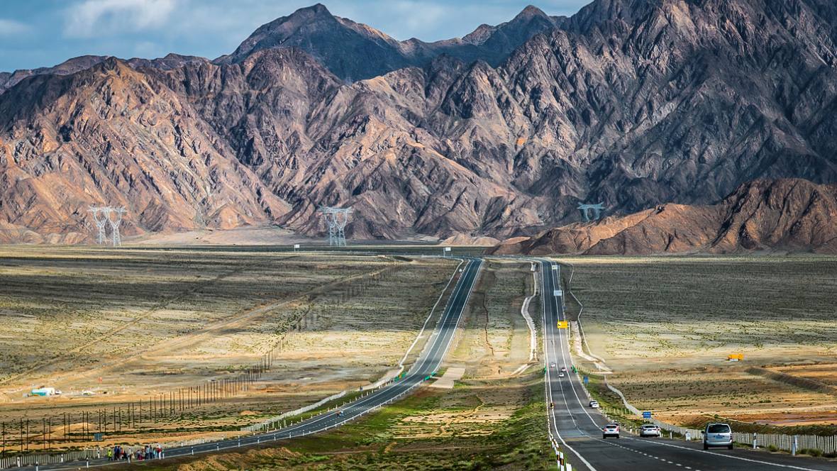
In the early morning, the sun rises from the sea level, and early risers can enjoy the most beautiful water Yadan sunrise. After taking photos of the sunrise and resting for a while, head to the popular U-shaped road. The popular road is the G315 National Road U-shaped road, also known as the popular road, located in Golmud City, Haixi Mongolian and Tibetan Autonomous Prefecture, Qinghai Province. The road surface dances with the undulating terrain, seemingly pointing directly to the sky, and is called the "Chinese version of Route 66." Along the G315 National Road, there are many attractions such as the Daqaidan Emerald Lake, the Wusute Yadan Geological Park, and the Dongtaijinaer Lake. As this road became popular online, many tourists came to check in. After checking in, continue south along the G315 National Road, with vast Gobi desert and endless sea of sand outside the car window, where one can truly appreciate the preciousness of life. Soon, we will enter the next stop, Chaka Salt Lake, via the Liuge Expressway. Chaka Salt Lake is a salt lake in the western part of Qinghai Province, known alongside Chaka Salt Lake, located in the southern part of the Qaidam Basin, spanning Golmud City and Dulan County. It is formed by the convergence of Dabuxun Lake and several salt pools such as South Hobson, North Hobson, and Senie, with a total area of 5,856 square kilometers. Several inland rivers, including the Golmud River and the Qaidam River, flow into this lake. Due to continuous evaporation, a hard salt crust forms on the salt lake, and the Qinghai-Tibet Railway and Qinghai-Tibet Highway are built directly on it. Chaka Salt Lake is rich in inorganic salts such as sodium chloride, potassium chloride, and magnesium chloride, with a total reserve of over 2 billion tons, making it one of China's mining bases. There is a famous salt bridge. Continuing south for 50 kilometers, we arrive at Golmud City, the second largest city in Qinghai. "Golmud" is a transliteration from Mongolian, meaning a place with dense rivers. It is located in the western part of Qinghai Province, in the hinterland of the Tibetan Plateau, and its jurisdiction consists of two non-contiguous areas in the southern part of the Qaidam Basin and the Tangula Mountain area. The urban area is located on the alluvial plain of the Golmud River in the southern part of the Qaidam Basin, with an average altitude of 2,780 meters, belonging to a plateau continental climate. [Note: It may not be convenient to eat during the journey today, please bring your own snacks.]
Day 6: Golmud—Yuzhu Peak—Kunlun Mountain Pass—Yuxu Peak—Kekexili—Qumalai [About 600 kilometers / Average altitude 4200 meters]
Starting today, the altitude of the journey will begin to rise. We will drive over the Kunlun Mountain (4776M) and proceed along the Qinghai-Tibet Line, with scenery along the way, from snow-capped mountains to grasslands, capturing the panoramic view of Yuzhu Peak (6178M) from the front at Xidatan. Today, I especially remind everyone to bring a telephoto lens, as we will pass through the Kekexili Nature Reserve where various wild animals can be photographed, such as Tibetan wild donkeys, foxes, etc. If lucky, we might also encounter Tibetan antelopes. As mentioned in the movie "Land of the Ancients," "Here, every footprint you leave may be the first footprint left by humanity." We will take distant shots of Yuxu Peak (5980M). In the afternoon, we will make a brief stop at the Kekexili Non-Frozen Spring Protection Station and head towards Qumalai in Yushu Tibetan Autonomous Prefecture via the northern source of the Yangtze River, the Chumar River. This area can be considered a true uninhabited zone, and we will stop along the way to take photos. The road passes through the reserve, which is home to very precious wildlife, including Tibetan antelopes, wild yaks, wild camels, and Tibetan wild donkeys. We will arrive at Qumalai, known as the first county of the Yangtze River, before dinner and check into a hotel to rest. [Note: Kekexili is known as the world's largest wilderness, a forbidden zone of life and also a continuation of life. The nature reserve is located in the western part of Yushu Tibetan Autonomous Prefecture, Qinghai Province, covering an area of 4.5 million hectares. It is one of the best-preserved primitive ecological environments in the world at the beginning of the 21st century, and also one of the largest, highest, and richest in wildlife resources in China. Here, snow-capped mountains are crisscrossed, lakes are scattered, and it is a paradise for wild animals, long regarded as the final pursuit for adventurers and photography enthusiasts. Today, the altitude will rise from about 2800 meters to around 4300 meters, with the highest altitude reaching about 5000M. Most people will experience varying degrees of altitude sickness, so please maintain a good mood, avoid strenuous exercise, and refrain from drinking alcohol. Qumalai is known as the first county of the Yangtze River, a county populated by Tibetans, with harsh conditions and limited local accommodation options. TIPS: It is recommended to bring a small telescope to look for wild animals in Kekexili.]
Day 7: Qumalai—New Zhai Mani Pile—Yushu [About 230 kilometers / Average altitude 3700 meters]
After breakfast, we will depart for the Yushu Earthquake Memorial Site, followed by a visit to the New Zhai Mani Pile. The New Zhai Mani Pile is the largest stone pile in the world, and it is said to have reached over 2 billion stones. In the evening, we will check into Yushu County. [Note: The altitude of Yushu County is about 3700M.]
Day 8: Yushu—Princess Temple—Lebagou—Jiegu Temple—Journey to the West Scripture Drying Platform—Yushu [About 330 kilometers / Average altitude 3700 meters]
We will set off early to the Princess Wencheng Temple, also known as the "Gasa Princess Temple," which is said to have been built by Tibetan people in the Tang Dynasty to commemorate Princess Wencheng. It is located in Yushu Tibetan Autonomous Prefecture, Qinghai Province, in the southeastern part of the Tibetan Plateau, known as the "Source of Three Rivers," and was established in the Tang Dynasty, with a history of over 1300 years. It is one of the important cultural relics of the ancient Tang-Tibet Road. In the afternoon, we will arrive at Lebagou, where the Lebagou rock paintings are located along the Tongtian River in Yushu Prefecture. Walking along a mountain path by the Tongtian River will evoke two completely different emotional experiences: the grandeur and tumult of the Tongtian River and the tranquility and sanctity of the Lebagou rock paintings. The Lebagou rock paintings are carved facing the river, located at the mouth of the Lebagou. The lush vegetation in Lebagou cannot conceal the mysterious atmosphere emanating from the rock paintings and the countless mani stones scattered throughout the gorge. From the Tang Dynasty's Shakyamuni statue at the gorge's entrance to the mani stones made today, you can see the entire history of Tibetan religious stone carvings. According to legend, when the monk Tang Seng and his three disciples traveled to the West to obtain scriptures, they were blocked by the surging and boundless Tongtian River when they reached Yushu. At that moment, a thousand-year-old turtle surfaced from the riverbed, carrying Tang Seng and his disciples across, and asked Tang Seng to inquire of the Tathagata about how much lifespan he had left. Upon reaching the Buddhist kingdom of India, Tang Seng sincerely worshipped the Buddha and focused on obtaining scriptures, forgetting the old turtle's request. Years later, when Tang Seng and his disciples returned from their journey, the old turtle helped them cross the Tongtian River again. When they reached the middle of the river, the old turtle suddenly asked about the request, and Tang Seng was speechless. The old turtle, knowing that Tang Seng had not inquired, in a fit of anger, threw Tang Seng and his disciples, along with their horses and scriptures, into the river.
Day 9: Yushu—Highland Wetland—Star Sea—Maduo [About 400 kilometers / Average altitude 4300 meters]
Today we leave Yushu County and head towards Maduo along National Highway 214. What unfolds before our eyes is an endless expanse of lakes and marshes. Looking around, the sparkling lakes, like stars scattered across the earth, are breathtaking. The Star Sea, a wonder formed by over four hundred lakes of various sizes, is an important water conservation area in the Sanjiangyuan region and the first stop of the desertification prevention project in Maduo County. We will stay overnight in Maduo County. [Note: Maduo County is about 4274M above sea level, with a cold climate and easy to experience hypoxia.]
Day 10: Maduo—Animaqing Sacred Mountain—Longyang Gorge Earth Forest—Longyang Gorge [About 500 kilometers / Average altitude 2700 meters]
After breakfast, we set off for Animaqing. Animaqing Mountain, also known as Maji Snow Mountain, means "the mountain of the great ancestor god" in Tibetan. Animaqing is a sacred mountain, a branch of the Kunlun Mountain range, and is known alongside Mount Kailash in Tibet, Meili Snow Mountain in Yunnan, and Gaduo Juewo in Yushu as one of the four sacred mountains in Tibetan Buddhism. It has 18 peaks over 5000 meters high, with 30 modern glaciers. The main peak, Maqing Gangri, is 6282M high, covered in snow year-round, and has many glaciers. It is rich in precious wildlife and minerals. "Ani" is the transliteration of the Amdo Tibetan word meaning ancestor or old man, also connoting beauty, happiness, or greatness; "Maqing" means the largest mountain at the source of the Yellow River, also implying magnificence. The Tibetan people refer to Animaqing as "Bokawa Jianggong," one of the nine great creation gods. We then head to the time town of Longyang Gorge, located in Hainan Tibetan Autonomous Prefecture, Gonghe County, at an altitude of 2700 meters. Influenced by geological activities, the area has formed a unique Danxia landform landscape characterized by plateau features, stretching over 50 kilometers, grand and magnificent, with vibrant colors mainly in red, brown, light green, and pale yellow, constantly changing under different lighting, resembling a flowing ink painting. We will stay overnight in Longyang Gorge Town.
Day 11: Longyang Gorge—Longyang Gorge Grand Canyon—Xining [About 130 kilometers / Average altitude 2200 meters]
Strolling through Longyang Gorge Town, known as the "Time Town," gives one a sense of time travel. The town gradually flourished with the construction of the Longyang Gorge Dam and was once referred to as "Little Hong Kong of Qinghai." After the dam was completed, many builders migrated away, and now it is a small town with only over 2000 residents, retaining many buildings from the 70s and 80s, becoming a precious witness to the industrial era of this quiet town. The Longyang Gorge Yellow River Grand Canyon is a breathtaking section of the Yellow River's course, comparable to the Grand Canyon in Colorado, USA. The steep and towering cliffs on both sides and the emerald waters in the middle can only be truly appreciated by taking a boat through it, making one feel how small humanity is in the face of nature! We will leave at the right time to return to Xining. Good times always pass too quickly; during these ten days of travel, we helped each other, communicated, and learned together, making it an unforgettable journey! Today, we have specially arranged a farewell dinner for everyone to conclude our adventure in Qinghai!
Day 12: Return to Beijing
Today we leave Xining and return to our warm home, concluding this self-driving journey!
Address: F509-5A Altantic Place, Chaoyang District, Beijing 100102, China
Telephone: 86-10-64751236 Fax: 86-10-64751236 E-mail: info@topchinatour.com

Copyright© Top China Tour Co.,Ltd.